Location:
This entry identifies the country's regional location, neighboring countries, and adjacent bodies of water.

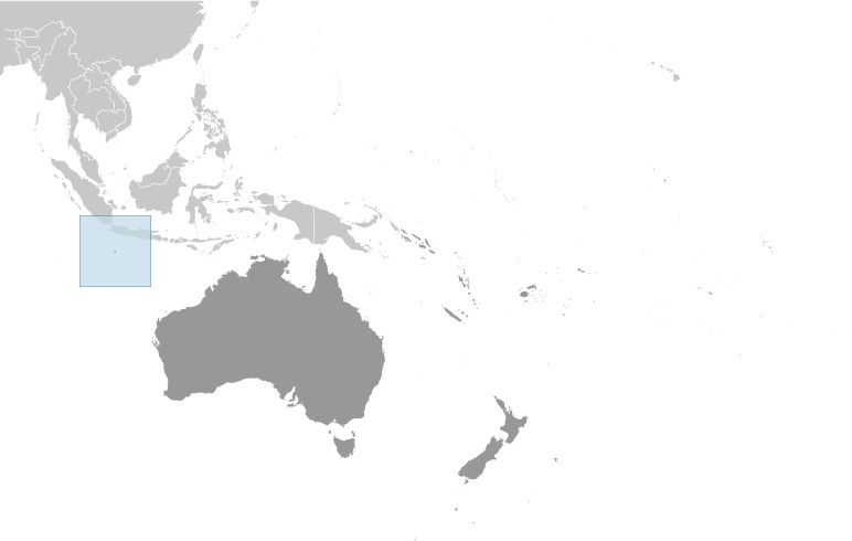
Southeastern Asia, island in the Indian Ocean, south of Indonesia
Geographic coordinates:
This entry includes rounded latitude and longitude figures for the centroid or center point of a country expressed in degrees and minutes; it is based on the locations provided in the Geographic Names Server (GNS), maintained by the National Geospatial-Intelligence Agency on behalf of the US Board on Geographic Names.
Map references:
This entry includes the name of the Factbook reference map on which a country may be found. Note that boundary representations on these maps are not necessarily authoritative. The entry on Geographic coordinates may be helpful in finding some smaller countries.
Area:
This entry includes three subfields. Total area is the sum of all land and water areas delimited by international boundaries and/or coastlines. Land area is the aggregate of all surfaces delimited by international boundaries and/or coastlines, excluding inland water bodies (lakes, reservoirs, rivers). Water area is the sum of the surfaces of all inland water bodies, such as lakes, reservoirs, or rivers, as delimited by international boundaries and/or coastlines.
total:
135 sq km
land:
135 sq km
water:
0 sq km
country comparison to the world:
221
Area - comparative:
This entry provides an area comparison based on total area equivalents. Most entities are compared with the entire US or one of the 50 states based on area measurements (1990 revised) provided by the US Bureau of the Census. The smaller entities are compared with Washington, DC (178 sq km, 69 sq mi) or The Mall in Washington, DC (0.59 sq km, 0.23 sq mi, 146 acres).
about three-quarters the size of Washington, DC
Land boundaries:
This entry contains the total length of all land boundaries and the individual lengths for each of the contiguous border countries. When available, official lengths published by national statistical agencies are used. Because surveying methods may differ, country border lengths reported by contiguous countries may differ.
Coastline:
This entry gives the total length of the boundary between the land area (including islands) and the sea.
Maritime claims:
This entry includes the following claims, the definitions of which are excerpted from the United Nations Convention on the Law of the Sea (UNCLOS), which alone contains the full and definitive descriptions: territorial sea - the sovereignty of a coastal state extends beyond its land territory and internal waters to an adjacent belt of sea, described as the territorial sea in the UNCLOS (Part II); this sovereignty extends to the air space over the territorial sea as well as its underlying s . . .
more
territorial sea:
12
nm
contiguous zone:
12
nm
exclusive fishing zone:
200
nm
Climate:
This entry includes a brief description of typical weather regimes throughout the year; in the Word entry only, it includes four subfields that describe climate extremes:ten driest places on earth (average annual precipitation) describes the annual average precipitation measured in both millimeters and inches for selected countries with climate extremes.
ten wettest places on earth (average annual precipitation) describes the annual average precipitation measured in both millimeters and i . . .
more
tropical with a wet season (December to April) and dry season; heat and humidity moderated by trade winds
Terrain:
This entry contains a brief description of the topography.
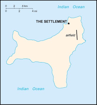
steep cliffs along coast rise abruptly to central plateau
Elevation:
This entry includes the mean elevation and elevation extremes, lowest point and highest point.
lowest point:
Indian Ocean 0 m
highest point:
Murray Hill 361 m
Natural resources:
This entry lists a country's mineral, petroleum, hydropower, and other resources of commercial importance, such as rare earth elements (REEs). In general, products appear only if they make a significant contribution to the economy, or are likely to do so in the future.
Land use:
This entry contains the percentage shares of total land area for three different types of land use: agricultural land, forest, and other; agricultural land is further divided into arable land - land cultivated for crops like wheat, maize, and rice that are replanted after each harvest, permanent crops - land cultivated for crops like citrus, coffee, and rubber that are not replanted after each harvest, and includes land under flowering shrubs, fruit trees, nut trees, and vines, and permane . . .
more
agricultural land:
0%
(2011 est.)
arable land:
0%
(2011 est.)
/
permanent crops:
0%
(2011 est.)
/
permanent pasture:
0%
(2011 est.)
other:
100%
(2011 est.)
Irrigated land:
This entry gives the number of square kilometers of land area that is artificially supplied with water.
Population distribution:
This entry provides a summary description of the population dispersion within a country. While it may suggest population density, it does not provide density figures.
majority of the population lives on the northern tip of the island
Natural hazards:
This entry lists potential natural disasters. For countries where volcanic activity is common, a volcanism subfield highlights historically active volcanoes.
the narrow fringing reef surrounding the island can be a maritime hazard
Environment - current issues:
This entry lists the most pressing and important environmental problems. The following terms and abbreviations are used throughout the entry:
Acidification - the lowering of soil and water pH due to acid precipitation and deposition usually through precipitation; this process disrupts ecosystem nutrient flows and may kill freshwater fish and plants dependent on more neutral or alkaline conditions (see acid rain).
Acid rain - characterized as containing harmful levels of sulfur dioxi . . .
more
loss of rainforest; impact of phosphate mining
Geography - note:
This entry includes miscellaneous geographic information of significance not included elsewhere.
located along major sea lanes of the Indian Ocean
Population:
This entry gives an estimate from the US Bureau of the Census based on statistics from population censuses, vital statistics registration systems, or sample surveys pertaining to the recent past and on assumptions about future trends. The total population presents one overall measure of the potential impact of the country on the world and within its region. Note: Starting with the 1993 Factbook, demographic estimates for some countries (mostly African) have explicitly taken into account t . . .
more
2,205
(2016 est.)
country comparison to the world:
230
Nationality:
This entry provides the identifying terms for citizens - noun and adjective.
noun:
Christmas Islander(s)
adjective:
Christmas Island
Ethnic groups:
This entry provides an ordered listing of ethnic groups starting with the largest and normally includes the percent of total population.
Chinese 70%, European 20%, Malay 10%
(2001)
note: no indigenous population
Languages:
This entry provides a listing of languages spoken in each country and specifies any that are official national or regional languages. When data is available, the languages spoken in each country are broken down according to the percent of the total population speaking each language as a first language. For those countries without available data, languages are listed in rank order based on prevalence, starting with the most-spoken language.
English (official) 27.6%, Mandarin 17.2%, Malay 17.1%, Cantonese 3.9%, Min Nan 1.6%, Tagalog 1%, other 4.5%, unspecified 27.1%
(2016 est.)
note: data represent language spoken at home
Religions:
This entry is an ordered listing of religions by adherents starting with the largest group and sometimes includes the percent of total population. The core characteristics and beliefs of the world's major religions are described below. Baha'i - Founded by Mirza Husayn-Ali (known as Baha'u'llah) in Iran in 1852, Baha'i faith emphasizes monotheism and believes in one eternal transcendent God. Its guiding focus is to encourage the unity of all peoples on the earth so that justice and peace m . . .
more
Muslim 19.4%, Buddhist 18.3%, Roman Catholic 8.8%, Protestant 6.5% (includes Anglican 3.6%, Uniting Church 1.2%, other 1.7%), other Christian 3.3%, other 0.6%, none 15.3%, unspecified 27.7%
(2016 est.)
Age structure:
This entry provides the distribution of the population according to age. Information is included by sex and age group as follows: 0-14 years (children), 15-24 years (early working age), 25-54 years (prime working age), 55-64 years (mature working age), 65 years and over (elderly). The age structure of a population affects a nation's key socioeconomic issues. Countries with young populations (high percentage under age 15) need to invest more in schools, while countries with older population . . .
more
0-14 years:
12.79%
(male 147/female 135)
(2017 est.)
15-24 years:
12.2%
(male 202/female 67)
(2017 est.)
25-54 years:
57.91%
(male 955/female 322)
(2017 est.)
55-64 years:
11.66%
(male 172/female 85)
(2017 est.)
65 years and over:
5.44%
(male 84/female 36)
(2017 est.)
Population growth rate:
The average annual percent change in the population, resulting from a surplus (or deficit) of births over deaths and the balance of migrants entering and leaving a country. The rate may be positive or negative. The growth rate is a factor in determining how great a burden would be imposed on a country by the changing needs of its people for infrastructure (e.g., schools, hospitals, housing, roads), resources (e.g., food, water, electricity), and jobs. Rapid population growth can be seen as . . .
more
1.11%
(2014 est.)
country comparison to the world:
94
Population distribution:
This entry provides a summary description of the population dispersion within a country. While it may suggest population density, it does not provide density figures.
majority of the population lives on the northern tip of the island
Sex ratio:
This entry includes the number of males for each female in five age groups - at birth, under 15 years, 15-64 years, 65 years and over, and for the total population. Sex ratio at birth has recently emerged as an indicator of certain kinds of sex discrimination in some countries. For instance, high sex ratios at birth in some Asian countries are now attributed to sex-selective abortion and infanticide due to a strong preference for sons. This will affect future marriage patterns and fertilit . . .
more
Infant mortality rate:
This entry gives the number of deaths of infants under one year old in a given year per 1,000 live births in the same year. This rate is often used as an indicator of the level of health in a country.
total:
NA
(2018)
male:
NA
female:
NA
Life expectancy at birth:
This entry contains the average number of years to be lived by a group of people born in the same year, if mortality at each age remains constant in the future. Life expectancy at birth is also a measure of overall quality of life in a country and summarizes the mortality at all ages. It can also be thought of as indicating the potential return on investment in human capital and is necessary for the calculation of various actuarial measures.
total population:
NA
(2017 est.)
male:
NA
female:
NA
Total fertility rate:
This entry gives a figure for the average number of children that would be born per woman if all women lived to the end of their childbearing years and bore children according to a given fertility rate at each age. The total fertility rate (TFR) is a more direct measure of the level of fertility than the crude birth rate, since it refers to births per woman. This indicator shows the potential for population change in the country. A rate of two children per woman is considered the replaceme . . .
more
HIV/AIDS - adult prevalence rate:
This entry gives an estimate of the percentage of adults (aged 15-49) living with HIV/AIDS. The adult prevalence rate is calculated by dividing the estimated number of adults living with HIV/AIDS at yearend by the total adult population at yearend.
HIV/AIDS - people living with HIV/AIDS:
This entry gives an estimate of all people (adults and children) alive at yearend with HIV infection, whether or not they have developed symptoms of AIDS.
HIV/AIDS - deaths:
This entry gives an estimate of the number of adults and children who died of AIDS during a given calendar year.
Country name:
This entry includes all forms of the country's name approved by the US Board on Geographic Names (Italy is used as an example): conventional long form (Italian Republic), conventional short form (Italy), local long form (Repubblica Italiana), local short form (Italia), former (Kingdom of Italy), as well as the abbreviation. Also see the Terminology note.
conventional long form:
Territory of Christmas Island
conventional short form:
Christmas Island
etymology:
named by English Captain William MYNORS for the day of its rediscovery, Christmas Day (25 December 1643); the island had been sighted by Europeans as early as 1615
Dependency status:
This entry describes the formal relationship between a particular nonindependent entity and an independent state.
non-self governing territory of Australia; administered from Canberra by the Department of Regional Australia, Local Government, Arts and Sport
Government type:
This entry gives the basic form of government. Definitions of the major governmental terms are as follows. (Note that for some countries more than one definition applies.):
Absolute monarchy - a form of government where the monarch rules unhindered, i.e., without any laws, constitution, or legally organized opposition.
Anarchy - a condition of lawlessness or political disorder brought about by the absence of governmental authority.
Authoritarian - a form of government in whic . . .
more
non-self-governing overseas territory of Australia
Capital:
This entry gives the name of the seat of government, its geographic coordinates, the time difference relative to Coordinated Universal Time (UTC) and the time observed in Washington, DC, and, if applicable, information on daylight saving time (DST). Where appropriate, a special note has been added to highlight those countries that have multiple time zones.
name:
The Settlement (Flying Fish Cove)
geographic coordinates:
10 25 S, 105 43 E
time difference:
UTC+7 (12 hours ahead of Washington, DC, during Standard Time)
etymology: self-descriptive name for the main locus of population
Administrative divisions:
This entry generally gives the numbers, designatory terms, and first-order administrative divisions as approved by the US Board on Geographic Names (BGN). Changes that have been reported but not yet acted on by the BGN are noted. Geographic names conform to spellings approved by the BGN with the exception of the omission of diacritical marks and special characters.
none (territory of Australia)
Independence:
For most countries, this entry gives the date that sovereignty was achieved and from which nation, empire, or trusteeship. For the other countries, the date given may not represent "independence" in the strict sense, but rather some significant nationhood event such as the traditional founding date or the date of unification, federation, confederation, establishment, fundamental change in the form of government, or state succession. For a number of countries, the establishment of statehood . . .
more
none (territory of Australia)
National holiday:
This entry gives the primary national day of celebration - usually independence day.
Australia Day (commemorates the arrival of the First Fleet of Australian settlers), 26 January (1788)
Constitution:
This entry provides information on a country’s constitution and includes two subfields. The history subfield includes the dates of previous constitutions and the main steps and dates in formulating and implementing the latest constitution. For countries with 1-3 previous constitutions, the years are listed; for those with 4-9 previous, the entry is listed as “several previous,” and for those with 10 or more, the entry is “many previous.” The amendments subfield summarizes the process of am . . .
more
history:
1 October 1958 (Christmas Island Act 1958)
amendments:
amended many times, last in 2016
Legal system:
This entry provides the description of a country's legal system. A statement on judicial review of legislative acts is also included for a number of countries. The legal systems of nearly all countries are generally modeled upon elements of five main types: civil law (including French law, the Napoleonic Code, Roman law, Roman-Dutch law, and Spanish law); common law (including United State law); customary law; mixed or pluralistic law; and religious law (including Islamic law). An addition . . .
more
legal system is under the authority of the governor general of Australia and Australian law
Citizenship:
This entry provides information related to the acquisition and exercise of citizenship; it includes four subfields: citizenship by birth describes the acquisition of citizenship based on place of birth, known as Jus soli, regardless of the citizenship of parents. citizenship by descent only describes the acquisition of citizenship based on the principle of Jus sanguinis, or by descent, where at least one parent is a citizen of the state and being born within the territorial limits of the s . . .
more
Suffrage:
This entry gives the age at enfranchisement and whether the right to vote is universal or restricted.
Executive branch:
This entry includes five subentries: chief of state; head of government; cabinet; elections/appointments; election results. Chief of state includes the name, title, and beginning date in office of the titular leader of the country who represents the state at official and ceremonial functions but may not be involved with the day-to-day activities of the government. Head of government includes the name, title of the top executive designated to manage the executive branch of the government, a . . .
more
chief of state:
Queen ELIZABETH II (since 6 February 1952); represented by Governor General of the Commonwealth of Australia General Sir Peter COSGROVE (since 28 March 2014)
head of government:
Administrator Natasha GRIGGS (since 5 October 2018)
elections/appointments:
the monarchy is hereditary; governor general appointed by the monarch on the recommendation of the Australian prime minister; administrator appointed by the governor general of Australia for a 2-year term and represents the monarch and Australia
Legislative branch:
This entry has three subfields. The description subfield provides the legislative structure (unicameral – single house; bicameral – an upper and a lower house); formal name(s); number of member seats; types of constituencies or voting districts (single seat, multi-seat, nationwide); electoral voting system(s); and member term of office. The elections subfield includes the dates of the last election and next election. The election results subfield lists percent of vote by party/coalition an . . .
more
description:
unicameral Christmas Island Shire Council (9 seats; members directly elected by simple majority vote to serve 4-year terms with a portion of the membership renewed every 2 years)
elections:
held every 2 years with half the members standing for election; last held on 21 October 2017 (next to be held in October 2019)
election results:
percent of vote - NA; seats by party - independent 9; composition as of 17 October 2015 - men 7, women 2, percent of women 22.2%
Judicial branch:
This entry includes three subfields. The highest court(s) subfield includes the name(s) of a country's highest level court(s), the number and titles of the judges, and the types of cases heard by the court, which commonly are based on civil, criminal, administrative, and constitutional law. A number of countries have separate constitutional courts. The judge selection and term of office subfield includes the organizations and associated officials responsible for nominating and appointing j . . .
more
under the terms of the Territorial Law Reform Act 1992, Western Australia provides court services as needed for the island, including the Supreme Court and subordinate courts (District Court, Magistrate Court, Family Court, Children's Court, and Coroners' Court)
Political parties and leaders:
This entry includes a listing of significant political parties, coalitions, and electoral lists as of each country's last legislative election, unless otherwise noted.
International organization participation:
This entry lists in alphabetical order by abbreviation those international organizations in which the subject country is a member or participates in some other way.
Diplomatic representation in the US:
This entry includes the chief of mission, chancery address, telephone, FAX, consulate general locations, and consulate locations. The use of the annotated title Appointed Ambassador refers to a new ambassador who has presented his/her credentials to the secretary of state but not the US president. Such ambassadors fulfill all diplomatic functions except meeting with or appearing at functions attended by the president until such time as they formally present their credentials at a White Hou . . .
more
none (territory of Australia)
Diplomatic representation from the US:
This entry includes the chief of mission, embassy address, mailing address, telephone number, FAX number, branch office locations, consulate general locations, and consulate locations.
none (territory of Australia)
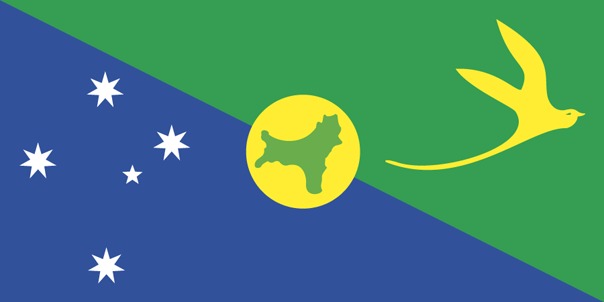
Flag description:
This entry provides a written flag description produced from actual flags or the best information available at the time the entry was written. The flags of independent states are used by their dependencies unless there is an officially recognized local flag. Some disputed and other areas do not have flags.
territorial flag; divided diagonally from upper hoist to lower fly; the upper triangle is green with a yellow image of the Golden Bosun Bird superimposed; the lower triangle is blue with the Southern Cross constellation, representing Australia, superimposed; a centered yellow disk displays a green map of the island
note: the flag of Australia is used for official purposes
National symbol(s):
A national symbol is a faunal, floral, or other abstract representation - or some distinctive object - that over time has come to be closely identified with a country or entity. Not all countries have national symbols; a few countries have more than one.
National anthem:
A generally patriotic musical composition - usually in the form of a song or hymn of praise - that evokes and eulogizes the history, traditions, or struggles of a nation or its people. National anthems can be officially recognized as a national song by a country's constitution or by an enacted law, or simply by tradition. Although most anthems contain lyrics, some do not.
note: as a territory of Australia, "Advance Australia Fair" remains official as the national anthem, while "God Save the Queen" serves as the royal anthem (see Australia)