Main Content


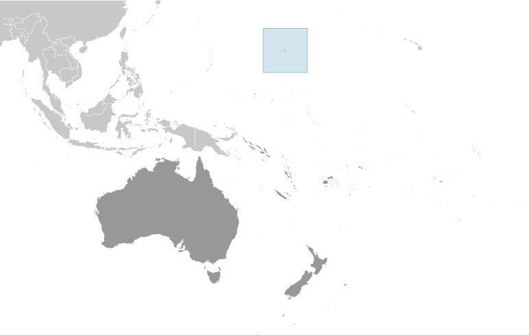
Australia - Oceania
::
Wake Island
Print
Page last updated on December 15, 2020

The World Factbook
Country/Location Flag Modal
Australia - Oceania ::
Wake Island
Print
Flag Description
the flag of the US is used
The World Factbook
Country/Location Locator Map Modal
Australia - Oceania ::
Wake Island
Print

The World Factbook
Country/Location Photo Gallery Modal
Australia - Oceania ::
Wake Island


1 /
9
Caption
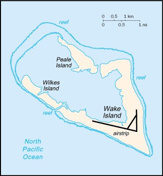
The atoll of Wake Island is composed of Wake Island proper and the smaller Peale and Wilkes Islands for a total land surface area of 6.5 sq km (2.5 sq mi). Like many atolls in the Pacific, the islands and associated reefs formed around a submerged volcano. The lagoon in the center of the islands marks the approximate location of the summit crater. Image courtesy of NASA.
Dimensions
File Size
Download
Usage
Factbook photos - obtained from a variety of sources - are in the public domain
and are copyright free.
Agency Copyright Notice
Agency Copyright Notice

2 /
9
Caption
Dramatic photo of Wake Island as seen past the refueling boom of a Boeing KC-135 Stratotanker aircraft. The view of the island is from the east. Photo courtesy of the US Air Force.
Dimensions
File Size
Download
Usage
Factbook photos - obtained from a variety of sources - are in the public domain
and are copyright free.
Agency Copyright Notice
Agency Copyright Notice

3 /
9
Caption
A closer view of Wake Island and its facilities. Photo courtesy of the US Air Force.
Dimensions
File Size
Download
Usage
Factbook photos - obtained from a variety of sources - are in the public domain
and are copyright free.
Agency Copyright Notice
Agency Copyright Notice

4 /
9
Caption
The airport terminal building on Wake Island. The island is a strategic air facility in the Western Pacific enabling the US to project power into the region. The airfield on Wake Island normally supports about 400 aircraft visits per year. Photo courtesy of the US Air Force.
Dimensions
File Size
Download
Usage
Factbook photos - obtained from a variety of sources - are in the public domain
and are copyright free.
Agency Copyright Notice
Agency Copyright Notice

5 /
9
Caption
United States Marine Corps memorial to the defenders of Wake Island in December 1941. For 16 days, beginning 8 December 1941, a combined military force of Marine ground and air units, Naval aviation personnel, and an Army detachment - augmented by civilian contractors - resisted near constant attacks by Japanese forces. In the end the island defenders were overwhelmed by the Japanese forces who then occupied the atoll until the end of World War II. Photo courtesy of the US Air Force.
Dimensions
File Size
Download
Usage
Factbook photos - obtained from a variety of sources - are in the public domain
and are copyright free.
Agency Copyright Notice
Agency Copyright Notice

6 /
9
Caption
Wake Island memorial to 98 civilian contractors killed by Japanese soldiers during their occupation of the island in World War II. Photo courtesy of the US Air Force.
Dimensions
File Size
Download
Usage
Factbook photos - obtained from a variety of sources - are in the public domain
and are copyright free.
Agency Copyright Notice
Agency Copyright Notice

7 /
9
Caption
An aerial view of Wilkes Island, one of the three islands making up Wake Atoll. Located on the west side of the atoll, Wilkes Island is now home to a bird sanctuary of approximately 12 different species of both sea and shore birds and about 40,000 birds total. This conservation effort is a joint project between the US Air Force and the US Fish and Wildlife Service of the Department of the Interior. Photo courtesy of the US Air Force.
Dimensions
File Size
Download
Usage
Factbook photos - obtained from a variety of sources - are in the public domain
and are copyright free.
Agency Copyright Notice
Agency Copyright Notice

8 /
9
Caption
A US Air Force B-2 bomber takes off from Wake Island airfield during a routine training exercise. The airfield on Wake Island is a strategic air facility that supports the projection of US military power into the Western Pacific. The airfield on Wake Island normally supports about 400 aircraft visits per year. Photo courtesy of the US Air Force.
Dimensions
File Size
Download
Usage
Factbook photos - obtained from a variety of sources - are in the public domain
and are copyright free.
Agency Copyright Notice
Agency Copyright Notice

9 /
9
Caption
A Terminal High-Altitude Area Defense interceptor is launched from a THAAD battery on Wake Island. In this test the THAAD system intercepted two air-launched ballistic-missile targets. Wake Island is an important launch facility for the Ronald Reagan Ballistic Missile Defense Test Site, managed by the US Missile Defense Agency from Kwajalein Atoll in the Marshall Islands. Photo courtesy of the US Missile Defense Agency.
Dimensions
File Size
Download
Usage
Factbook photos - obtained from a variety of sources - are in the public domain
and are copyright free.
Agency Copyright Notice
Agency Copyright Notice
-
Introduction :: Wake Island
-
 The US annexed Wake Island in 1899 for a cable station. An important air and naval base was constructed in 1940-41. In December 1941, the island was captured by the Japanese and held until the end of World War II. In subsequent years, Wake became a stopover and refueling site for military and commercial aircraft transiting the Pacific. Since 1974, the island's airstrip has been used by the US military, as well as for emergency landings. Operations on the island were temporarily suspended and all personnel evacuated in 2006 with the approach of super typhoon IOKE (category 5), but resultant damage was comparatively minor. A US Air Force repair team restored full capability to the airfield and facilities, and the island remains a vital strategic link in the Pacific region.
 -
Geography :: Wake Island
-
Oceania, atoll in the North Pacific Ocean, about two-thirds of the way from Hawaii to the Northern Mariana Islands
19 17 N, 166 39 E
Oceania
about 11 times the size of the National Mall in Washington, DC
0 km
19.3 km
territorial sea: 12 nmexclusive economic zone: 200 nm
tropical
atoll of three low coral islands, Peale, Wake, and Wilkes, built up on an underwater volcano; central lagoon is former crater, islands are part of the rim
lowest point: Pacific Ocean 0 mhighest point: unnamed location 8 m
none
agricultural land: 0% (2011 est.)arable land: 0% (2011 est.) / permanent crops: 0% (2011 est.) / permanent pasture: 0% (2011 est.)forest: 0% (2011 est.)other: 100% (2011 est.)
0 sq km (2012)
subject to occasional typhoons
potable water obtained through a catchment rainwater system and a desalinization plant for brackish ground water; hazardous wastes moved to an accumulation site for storage and eventual transport off site via barge
strategic location in the North Pacific Ocean; emergency landing location for transpacific flights
-
People and Society :: Wake Island
-
no indigenous inhabitants (2018 est.)
note: approximately 100 military personnel and civilian contractors maintain and operate the airfield and communications facilities
-
Government :: Wake Island
-
conventional long form: noneconventional short form: Wake Islandetymology: although first discovered by British Captain William WAKE in 1792, the island is named after British Captain Samuel WAKE, who rediscovered the island in 1796
unincorporated unorganized territory of the US; administered from Washington, DC, by the Department of the Interior; activities in the atoll are currently conducted by the 11th US Air Force and managed from Pacific Air Force Support Center
none (territory of the US)
US common law
see United States
the flag of the US is used
-
Economy :: Wake Island
-
Economic activity is limited to providing services to military personnel and contractors located on the island. All food and manufactured goods must be imported.
-
Energy :: Wake Island
-
electrification - total population: 100% (2020)
0 bbl/day (2018 est.)country comparison to the world: 216
-
Communications :: Wake Island
-
general assessment: satellite communications; 2 Defense Switched Network circuits off the Overseas Telephone System (OTS); located in the Hawaii area code - 808 (2018)
American Armed Forces Radio and Television Service (AFRTS) provides satellite radio/TV broadcasts (2018)
-
Transportation :: Wake Island
-
1 (2018)country comparison to the world: 237
total: 1 (2019)2,438 to 3,047 m: 1
none; two offshore anchorages for large ships
there are no commercial or civilian flights to and from Wake Island, except in direct support of island missions; emergency landing is available
-
Military and Security :: Wake Island
-
defense is the responsibility of the US; the US Air Force is responsible for overall administration and operation of the island facilities; the launch support facility is administered by the US Missile Defense Agency (MDA)
-
Transnational Issues :: Wake Island
-
claimed by Marshall Islands