Main Content


Australia - Oceania
::
Palmyra Atoll
Print
Page last updated on December 17, 2020
The World Factbook
Country/Location Flag Modal
Australia - Oceania ::
Palmyra Atoll
Print
Flag Description
the flag of the US is used
The World Factbook
Country/Location Locator Map Modal
Australia - Oceania ::
Palmyra Atoll
Print

The World Factbook
Country/Location Photo Gallery Modal
Australia - Oceania ::
Palmyra Atoll

1 /
1
Caption
Palmyra Atoll is an equatorial Northern Pacific atoll administered as an unorganized incorporated territory by the US federal government. The variable temporary population consists of 4-20 "non-occupants" who are staff and scientists employed by various departments of the US Government and The Nature Conservancy, as well as a rotating mix of Palmyra Atoll Research Consortium scholars pursuing research. Palmyra is located almost due south of the Hawaiian Islands, roughly halfway between Hawaii and American Samoa.
Dimensions
File Size
Download
Usage
Factbook photos - obtained from a variety of sources - are in the public domain
and are copyright free.
Agency Copyright Notice
Agency Copyright Notice
-
Introduction :: Palmyra Atoll
-
 The Kingdom of Hawaii claimed the atoll in 1862, and the US included it among the Hawaiian Islands when it annexed the archipelago in 1898. The Hawaii Statehood Act of 1959 did not include Palmyra Atoll, which is now part privately owned by the Nature Conservancy and part US Government-owned and administered as a nature preserve. The lagoons and surrounding waters within the 12-nautical-mile US territorial seas were transferred to the US Fish and Wildlife Service and were designated a National Wildlife Refuge in January 2001.
 -
Geography :: Palmyra Atoll
-
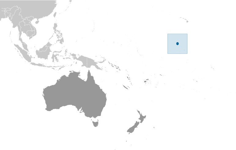
Oceania, atoll in the North Pacific Ocean, about half way between Hawaii and American Samoa
5 52 N, 162 04 W
Oceania
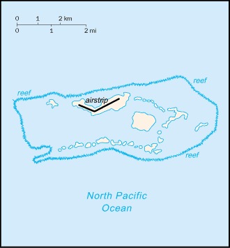
about 20 times the size of The Mall in Washington, DC
0 km
14.5 km
territorial sea: 12 nmexclusive economic zone: 200 nm
equatorial, hot, and very rainy
very lowlying atoll consists of an extensive reef, two shallow lagoons, and about 50 islets and bars covered with vegetation
mean elevation: 2 mlowest point: Pacific Ocean 0 mhighest point: unnamed location on Sand Island 10 m
terrestrial and aquatic wildlife
an extensive surrounding reef is only penetrated by a single western channel
a few of the islets are designated Unexploded Ordnance Areas, a legacy of US Navy occupation (1934-59), and are closed to entry; invasive plants and insects compete with native biota
about 50 islets covered with dense vegetation, coconut trees, and balsa-like trees up to 30 meters tall
-
People and Society :: Palmyra Atoll
-
no indigenous inhabitants (July 2014 est.)
note: variable temporary population of 4 to 20 staff and scientists of the Nature Conservancy and the US Fish and Wildlife Service
-
Government :: Palmyra Atoll
-
conventional long form: noneconventional short form: Palmyra Atolletymology: named for the USS Palmyra, which was shipwrecked on the reef in 1802
incorporated territory of the US; privately owned but administered from Washington, DC, by the Fish and Wildlife Service of the US Department of the Interior; the Office of Insular Affairs of the US Department of the Interior continues to administer nine excluded areas comprising certain tidal and submerged lands within the 12 nm territorial sea limit or within the lagoon
the laws of the US apply where applicable
the flag of the US is used
-
Transportation :: Palmyra Atoll
-
total: 1 (2013)1,524 to 2,437 m: 1 (2013)
West Lagoon
-
Military and Security :: Palmyra Atoll
-
defense is the responsibility of the US
-
Transnational Issues :: Palmyra Atoll
-
none