Main Content


Australia - Oceania
::
Johnston Atoll
Print
Page last updated on December 17, 2020
The World Factbook
Country/Location Flag Modal
Australia - Oceania ::
Johnston Atoll
Print
Flag Description
the flag of the US is used
The World Factbook
Country/Location Locator Map Modal
Australia - Oceania ::
Johnston Atoll
Print

The World Factbook
Country/Location Photo Gallery Modal
Australia - Oceania ::
Johnston Atoll

1 /
1
Caption
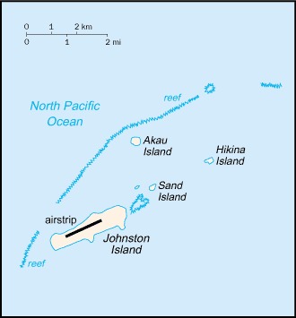
Satellite photo of Johnston Atoll, about 1,390 km (860 mi) west of Hawaii. Four islands compose the total land mass of 2.6 sq km. Johnston and Sand islands are both enlarged natural features, while Akau and Hikina are two artificial islands formed by coral dredging. Johnston Island, by far the largest, contains an airstrip. Image courtesy of NASA.
Dimensions
File Size
Download
Usage
Factbook photos - obtained from a variety of sources - are in the public domain
and are copyright free.
Agency Copyright Notice
Agency Copyright Notice
-
Introduction :: Johnston Atoll
-
 Both the US and the Kingdom of Hawaii annexed Johnston Atoll in 1858, but it was the US that mined the guano deposits until the late 1880s. Johnston Island and Sand Island were designated wildlife refuges in 1926. The US Navy took over the atoll in 1934, and subsequently the US Air Force assumed control in 1948. The site was used for high-altitude nuclear tests in the 1950s and 1960s, and until late in 2000 the atoll was maintained as a storage and disposal site for chemical weapons. Cleanup and closure of the weapons facility ended in May 2005.
 -
Geography :: Johnston Atoll
-
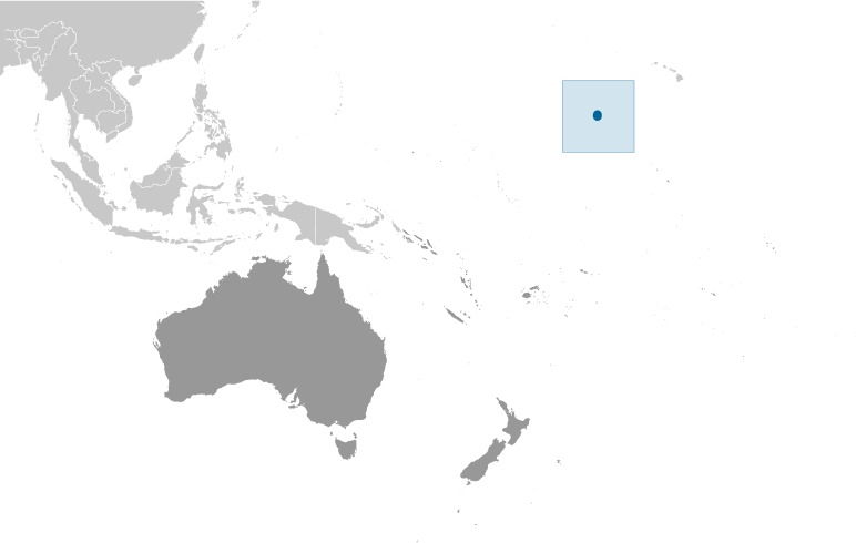
Oceania, atoll in the North Pacific Ocean 1328 km southwest of Honolulu, Hawaii, about one-third of the way from Hawaii to the Marshall Islands
16 45 N, 169 31 W
Oceania
about 4.7 times the size of The Mall in Washington, DC
0 km
34 km
territorial sea: 12 nmexclusive economic zone: 200 nm
tropical, but generally dry; consistent northeast trade winds with little seasonal temperature variation
mostly flat
guano deposits (worked until about 1890), terrestrial and aquatic wildlife
occasional tropical cyclones; coral reef to the north and west of the atoll is a maritime hazard
no natural fresh water resources
strategic location in the North Pacific Ocean; Johnston Island and Sand Island are natural islands, which have been expanded by coral dredging; North Island (Akau) and East Island (Hikina) are manmade islands formed from coral dredging; the egg-shaped reef is 34 km in circumference; closed to the public; a former US nuclear weapons test site; site of now-closed Johnston Atoll Chemical Agent Disposal System (JACADS); most facilities dismantled and cleanup complete in 2004; some low-growing vegetation
-
People and Society :: Johnston Atoll
-
uninhabited
note: in previous years, there was an average of 1,100 US military and civilian contractor personnel present; as of September 2001, population had decreased significantly when US Army Chemical Activity Pacific (USACAP) departed; as of May 2005 all US Government personnel had left the island
-
Government :: Johnston Atoll
-
conventional long form: noneconventional short form: Johnston Atolletymology: although first encountered in 1796, the islands were named after Captain Charles JOHNSTON, who sighted them in 1807
unincorporated territory of the US; administered from Honolulu, Hawaii, by Pacific Air Forces, Hickam Air Force Base, and the Fish and Wildlife Service of the US Department of the Interior as part of the National Wildlife Refuge System
the laws of the US apply where applicable
the flag of the US is used
-
Transportation :: Johnston Atoll
-
total: 1 (2013)2,438 to 3,047 m: 1 (2013)
Johnston Island
-
Military and Security :: Johnston Atoll
-
defense is the responsibility of the US
-
Transnational Issues :: Johnston Atoll
-
none