Australia - Oceania ::
Jarvis Island
-
Introduction :: Jarvis Island
-
Background:First discovered by the British in 1821, the uninhabited island was annexed by the US in 1858 but abandoned in 1879 after tons of guano deposits had been removed for use in producing fertilizer. The UK annexed the island in 1889 but never carried out plans for further exploitation. The US occupied and reclaimed the island in 1935. Abandoned after World War II, the island is currently a National Wildlife Refuge administered by the US Department of the Interior.
-
Geography :: Jarvis Island
-
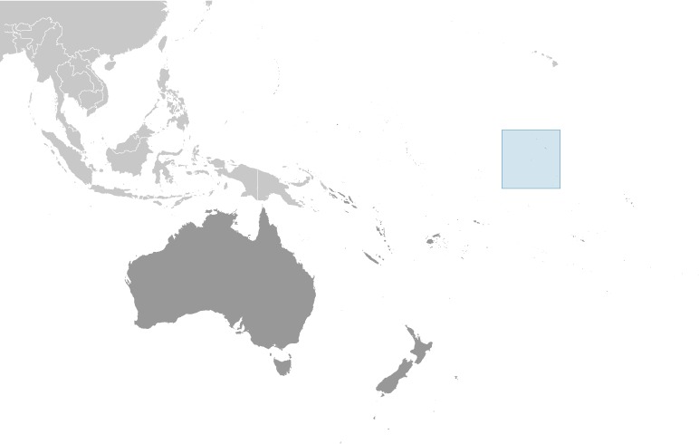
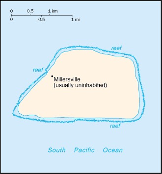
Location:Oceania, island in the South Pacific Ocean, about half way between Hawaii and the Cook IslandsGeographic coordinates:0 22 S, 160 01 WMap references:OceaniaArea:total: 5 sq kmland: 4.5 sq kmwater: 0 sq kmcountry comparison to the world: 251Area - comparative:about eight times the size of The Mall in Washington, DCLand boundaries:0 kmCoastline:8 kmMaritime claims:territorial sea: 12 nmexclusive economic zone: 200 nmClimate:tropical; scant rainfall, constant wind, burning sunTerrain:sandy, coral island surrounded by a narrow fringing reefNatural resources:guano (deposits worked until late 1800s), terrestrial and aquatic wildlifeNatural hazards:the narrow fringing reef surrounding the island poses a maritime hazardEnvironment - current issues:no natural fresh water resourcesGeography - note:sparse bunch grass, prostrate vines, and low-growing shrubs; primarily a nesting, roosting, and foraging habitat for seabirds, shorebirds, and marine wildlife
-
People and Society :: Jarvis Island
-
Population:uninhabited
note: Millersville settlement on western side of island occasionally used as a weather station from 1935 until World War II, when it was abandoned; reoccupied in 1957 during the International Geophysical Year by scientists who left in 1958; public entry is by special-use permit from US Fish and Wildlife Service only and generally restricted to scientists and educators; visited annually by US Fish and Wildlife Service
-
Government :: Jarvis Island
-
Country name:conventional long form: noneconventional short form: Jarvis Islandetymology: named after three brothers JARVIS, the owners of the British ship from which the island was discovered in 1821Dependency status:unincorporated territory of the US; administered from Washington, DC, by the Fish and Wildlife Service of the US Department of the Interior as part of the National Wildlife Refuge SystemLegal system:the laws of the US apply where applicableFlag description:the flag of the US is used
-
Transportation :: Jarvis Island
-
Ports and terminals:none; offshore anchorage only; note - there is one small boat landing area in the middle of the west coast and another near the southwest corner of the islandTransportation - note:there is a day beacon near the middle of the west coast
-
Military and Security :: Jarvis Island
-
Military - note:defense is the responsibility of the US; visited periodically by the US Coast Guard
-
Transnational Issues :: Jarvis Island
-
Disputes - international:
none